Average Speed vs. Posted Speed Limit
Updated Using 2022 Data

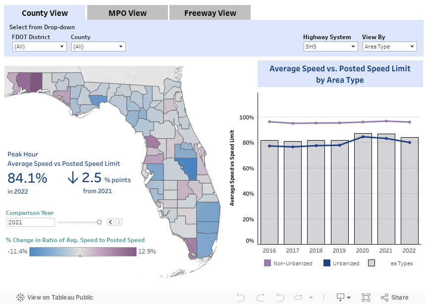
This measure represents the percent of the posted speed limit achieved by all vehicles during the peak hour. In general, travelers are able to achieve speeds closer to the posted speed limit on highways than on arterials.

Methodology

Methodology: Average Speed vs. Posted Speed Limit

This measure is expressed as the ratio of average peak hour speed against the posted speed limit. The output represents the percent of the posted speed limit achieved during the peak hour . The average peak hour speed for an area is the average of all hourly roadway segment travel speeds captured by HERE probe speed data or modeled through speed-volume functions, weighted by the segment’s vehicle miles traveled (VMT). A very small number of roadway segments do not have HERE speed probe data coverage. For those segments, speed-volume functions are used to determine the speed.

Calculation

`"Average Speed vs Posted Speed" = (∑VMT × "(""Peak Hour Speed"/"Posted Speed Limit"")" )/(∑VMT)`

Reporting Periods

  • Peak Hour
  • Peak Period
  • Daily
  • Yearly
Definitions

Definitions: Average Speed vs. Posted Speed Limit

  • Area Type
    • Urbanized Area: An area with a population of at least 50,000 people.
    • Non-Urbanized Area: An area with a population less than 50,000 people.
  • Average Speed vs Posted Speed Limit: Percent of the posted speed limit achieved by all vehicles during the peak hour.
  • Context Classification: A classification assigned to a roadway that broadly identifies the various built environments in Florida, based on existing or future land use characteristics, development patterns, and the roadway connectivity of an area. For more information about context class, please reference methodology document.
  • Facility Type
    • Arterials: Signalized roadways that primarily serve through traffic with average signalized intersection spacing of two miles or less.
    • Highways: High speed roadways with signal spacing greater than two miles per signal.
    • Freeway: A multilane, divided highway with at least two lanes for exclusive use of traffic in each direction and full control of ingress and egress.
  • Highway System: An integrated network of roads and highways for motor and non-motor transport. Each highway system has roadways that are exclusive to their respective system.
    • National Highway System (NHS): Roads designated by Congress as nationally important for inter-regional travel, including roads designated as connectors to NHS intermodal facilities.
    • State Highway System (SHS): Roads under the jurisdiction of the State of Florida, and maintained by the Florida Department of Transportation or a regional transportation commission; includes roads with Interstate, US, and SR numbers.
    • Strategic Intermodal System (SIS): Transportation system created by the Florida Legislature in 2003 to include statewide and regionally significant facilities and services, containing all forms of transportation for moving both people and goods, including linkages that provide for smooth and efficient transfers between modes and major facilities.
  • Reporting Periods
    • Peak Hour: 5:00 p.m. to 6:00 p.m. on a weekday. This hour is chosen to allow consistent comparisons among transportation modes. It may not be the hour of greatest travel for any given roadway, mode or area. The majority of travel typically occurs during the PM peak hour resulting in more congestion in the PM peak than observed in the AM peak.
  • Segment: A portion of roadway defined by two boundary points.

Download Data

Date of last refresh: 10/19/2023

SOURCES

FDOT - Roadway Characteristics Inventory Feature 311 (Speed Limits)
FDOT - Traffic Characteristics Inventory
HERE Technologies - Travel Time Data