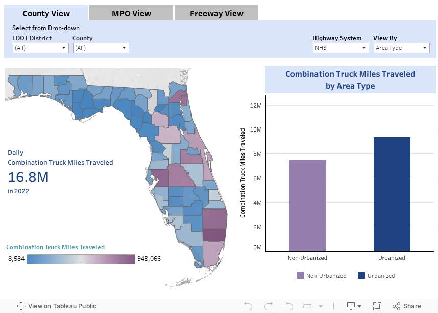
Combination Truck Miles Traveled
New
Combination truck miles traveled is the total number of miles driven by combination trucks on a roadway within a region.
Methodology
Definitions
Download Data
Methodology: Combination Truck Miles Traveled
Combination Truck Miles Traveled (CTMT) is computed by multiplying vehicle miles traveled (VMT) by the combination truck factor. The combination truck factor is provided on a county-by-county basis and represents the proportion of heavy vehicles that are combination trucks (Classes 8-13)
Calculation
`"Combination Truck Miles Traveled" = ∑"(VMT" × "CT Factor)"`
Reporting Periods
- Peak Hour
- Peak Period
- Daily
- Yearly
Definitions: Combination Truck Miles Traveled
- Annual Average Daily Traffic (AADT): The total volume of traffic on a highway segment for one year, divided by the number of days in the year.
- Area Type
- Urbanized Area: An area with a population of at least 50,000 people.
- Non-Urbanized Area: An area with a population less than 50,000 people.
- Combination Trucks: Trucks with vehicle classification from 8 to 13.
- Combination Truck Factor: Represents the proportion of heavy vehicles that are combination trucks (Classes 8-13).
- Context Classification: A classification assigned to a roadway that broadly identifies the various built environments in Florida, based on existing or future land use characteristics, development patterns, and the roadway connectivity of an area. For more information about context class, please reference methodology document.
- Facility Type
- Arterials: Signalized roadways that primarily serve through traffic with average signalized intersection spacing of two miles or less.
- Highways: High speed roadways with signal spacing greater than two miles per signal.
- Freeway: A multilane, divided highway with at least two lanes for exclusive use of traffic in each direction and full control of ingress and egress.
- Highway System: An integrated network of roads and highways for motor and non-motor transport. Each highway system has roadways that are exclusive to their respective system.
- National Highway System (NHS): Roads designated by Congress as nationally important for inter-regional travel, including roads designated as connectors to NHS intermodal facilities.
- State Highway System (SHS): Roads under the jurisdiction of the State of Florida, and maintained by the Florida Department of Transportation or a regional transportation commission; includes roads with Interstate, US, and SR numbers.
- Strategic Intermodal System (SIS): Transportation system created by the Florida Legislature in 2003 to include statewide and regionally significant facilities and services, containing all forms of transportation for moving both people and goods, including linkages that provide for smooth and efficient transfers between modes and major facilities.
- Reporting Periods
- Daily: For the average 24-hour day.
- Segment: A portion of roadway defined by two boundary points.
Date of last refresh: 01/19/2024
SOURCES
FDOT - Roadway Characteristics Inventory
FDOT - Traffic Characteristics Inventory
FDOT - Weigh-In-Motion Data