Planning Time Index
Updated Using 2022 Data

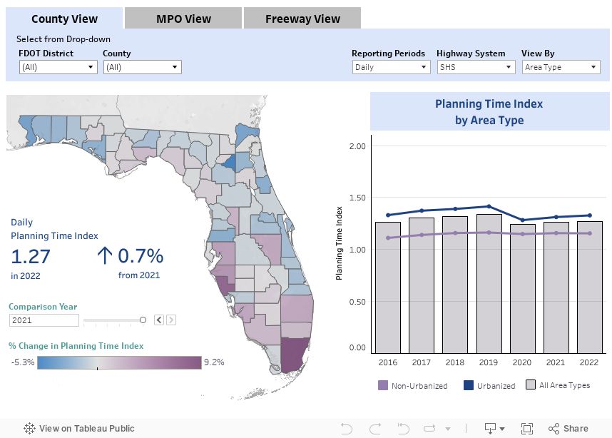
Travel time reliability measures the extent of the unexpected delay a traveler experiences. Planning Time Index (PTI) measures the total travel time that a traveler should budget for a trip to ensure on-time arrival to their destination at least 95% of the time. It's one of several ways to measure travel time reliability, i.e., consistency and dependability of travel times. The higher the PTI, the less reliable an arrival time is and more time needs to be set aside in order to arrive at the destination on time.

Methodology

Methodology: Planning Time Index

Planning Time Index (PTI) is the ratio of the 95ᵗʰ percentile travel time to the travel time at reference speed defined as the 85ᵗʰ percentile speed during weekday off-peak hours (9 am to 4 pm and 7 pm to 10 pm). This measure represents the total travel time that a traveler should budget to ensure on-time arrival 95% of the time. PTI uses field-measured travel speed data, provided by HERE Technologies through the Regional Integrated Transportation Information System (RITIS) at the University of Maryland’s Center for Advanced Transportation Technology Laboratory (CATT Lab). The field-measured travel speed data covers most of the State Highway System (SHS) and National Highway System (NHS) roadways. On roadways where the speed data does not cover the SHS or NHS, the PTI is calculated based on speeds estimated from speed volume functions.

Calculation

`"Planning Time Index" = "Travel Time"_("95th percentile")/"Travel Time"_("reference speed")`

Reporting Periods

  • Peak Hour
  • Peak Period
  • Daily
  • Yearly
Definitions

Definitions: Planning Time Index

  • Annual Average Daily Traffic (AADT): The total volume of traffic on a highway segment for one year, divided by the number of days in the year.
  • Area Type
    • Urbanized Area: An area with a population of at least 50,000 people.
    • Non-Urbanized Area: An area with a population less than 50,000 people.
  • Context Classification: A classification assigned to a roadway that broadly identifies the various built environments in Florida, based on existing or future land use characteristics, development patterns, and the roadway connectivity of an area. For more information about context class, please reference methodology document.
  • Facility Type
    • Arterials: Signalized roadways that primarily serve through traffic with average signalized intersection spacing of two miles or less.
    • Highways: High speed roadways with signal spacing greater than two miles per signal.
    • Freeway: A multilane, divided highway with at least two lanes for exclusive use of traffic in each direction and full control of ingress and egress.
  • Highway System: An integrated network of roads and highways for motor and non-motor transport. Each highway system has roadways that are exclusive to their respective system.
    • National Highway System (NHS): Roads designated by Congress as nationally important for inter-regional travel, including roads designated as connectors to NHS intermodal facilities.
    • State Highway System (SHS): Roads under the jurisdiction of the State of Florida, and maintained by the Florida Department of Transportation or a regional transportation commission; includes roads with Interstate, US, and SR numbers.
    • Strategic Intermodal System (SIS): Transportation system created by the Florida Legislature in 2003 to include statewide and regionally significant facilities and services, containing all forms of transportation for moving both people and goods, including linkages that provide for smooth and efficient transfers between modes and major facilities.
  • Planning Time Index (PTI): The ratio of the 95ᵗʰ percent travel time to the reference speed travel time.
  • Reporting Periods
    • Peak Hour: 5:00 p.m. to 6:00 p.m. on a weekday. This hour is chosen to allow consistent comparisons among transportation modes. It may not be the hour of greatest travel for any given roadway, mode or area. The majority of travel typically occurs during the PM peak hour resulting in more congestion in the PM peak than observed in the AM peak.
    • Peak Period: 4:00 p.m. to 6:00 p.m. on a weekday in which travel is greatest. These peak period hours are chosen based on the hours of greatest travel in different area types.
    • Daily: For the average 24-hour day.
  • Segment: A portion of roadway defined by two boundary points.
Download Data

Date of last refresh: 10/19/2023

SOURCES

FDOT - Traffic Characteristics Inventory
FDOT - Roadway Characteristics Inventory Feature 147 (Strategic Intermodal System)
HERE Technologies - Travel Time Data